
FOR IMMEDIATE RELEASE: May 9, 2019
MEDIA CONTACTS: Carole Trottere, Rebecca Cheng, Vicki DiStefano and Matt Leonenko | (516) 869-7794
Town of North Hempstead Partners with Port North for GIS Mapping Project
North Hempstead, NY – North Hempstead Town Supervisor Judi Bosworth, the Town Board, and Port Washington North Village Mayor Bob Weitzner announced today that a joint Geographic Informational System (GIS) mapping and inventory project of Town and Village assets has been completed, giving officials a central data base of all roads and surface features, including roadways, sidewalks, hydrants, signs and street lighting, that can be used as a tool to track location, condition and age of assets, as well as measure maintenance costs and depreciation. The Town has over 300 miles of roads; the Village of Port North has about 10 miles.
“Inter-municipal coordination is a high priority in North Hempstead as it improves the way governments and municipalities communicate, and provides the highest level of services at reduced costs for our taxpayers,” Supervisor Bosworth said. “This mapping and inventory project will enable the Town to respond quicker to maintenance issues and to better assess the condition of our roadways.”
Under this plan, a resident could call 311 stating that a street sign is missing, and rather than a Highway Department employee physically leaving to survey the situation, they can access the GIS database, see what sign is needed, and then go to the site to install it, saving both time and money. It also allows for governments to have the information available in a database rather than relying on employees’ institutional knowledge.
The project was funded with a $270,000 Local Government Efficiency Program grant from the New York State Department of State. The project will create a central database of surface assets allowing the Town and Village governments to work together to create cost-effective plans for managing them. The goal of the project is to improve inter-municipal government efficiency, boost citizen engagement, and save taxpayer dollars.
The actual capturing of data was conducted by Transmap, an Ohio-based company that specializes in the mobile data collection, processing, analysis and inventory of roadway assets, such as traffic signs and pavement condition.
“The Village is delighted to continue our long standing working relationship with the Town of North Hempstead on this important initiative. Any tool that can assist with our inventorying and rating of our assets will be immensely valuable to our planning and budgeting process. Since we have a fully functional GIS system in place, we will be able to take full advantage of the data that is created by this project. Ultimately, this will save our Village time and money,” said Robert Weitzner, Mayor of Port Washington North.
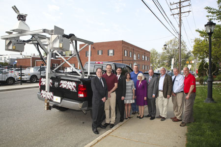
Standing next to the Tranmap surveying GIS mapping truck are, from left are Tax Receiver Charles Berman, Grants Coordinator Thomas Devaney, Town Clerk Wayne Wink, Council member Dina DeGiorgio, Town Kevin Limongelli, Town Supervisor Judi Bosworth, Council Member Peter Zuckerman, Village of Port North Mayor Robert Weitzner, Highway Superintendent Richard Baker and Transmap Vice President Craig Schorling GISP.